Sentinel Peak/A-mountain
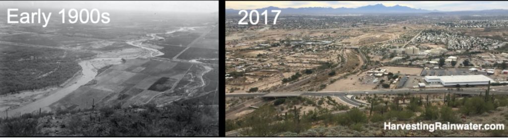
A view of how the Santa Cruz River and Tucson Basin ecology/hydrology is changing
Offers a good view of the Tucson Basin and Santa Cruz River, which you can compare to historic views/photos to see how things have changed in recent history.
Below this peak, multiple radiocarbon dates consistently show that the earliest maize was cultivated 4,100 years ago) along the flood plain of the Santa Cruz River. This date makes this area (including Tumamoc Hill) the longest continuously inhabited site in the United States. The Santa Cruz River was a major source of the early people’s drinking water, irrigation water, and fish.
The Spaniards arrived in the 17th century when Tohono O’odham settlements were throughout the area. One O’odham settlement called “Schuk-Shon,” meaning “at the foot of the black mountain,” was pronounced “Tuk-Son” by the Spaniards.
The once perennially-flowing Santa Cruz River—and the dense food-bearing bosque/forest of velvet and screwbean mesquites, cottonwood, Arizona walnut, willow, and canyon hackberry trees that used to grow along the river’s banks within its floodplain—was also at the base of this black mountain.
The river flow, and its floodplain forests began to subside in the late 1800s/early 1900s when groundwater tables dropped after settlers began using groundwater pumps, and caused headcut erosion within the riverbed and its tributaries due to destructive river diversions and failed dams. By the 1950s the perennial flow of the river was gone because the rate of groundwater pumping/extraction far exceeded the rate of natural recharge of that groundwater, while much of the watershed had been denuded of, or paved over, its rainfall-absorbent living sponges of vegetation and topsoil.
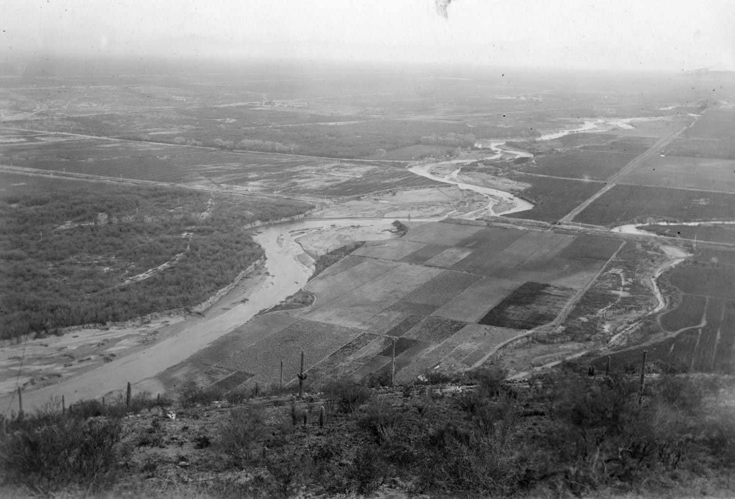
Note the meandering, flowing river and the rich sponge of vegetation throughout the watershed (especially where the native forests of mesquite, canyon hackberry, willow, and cottonwood trees have not yet been replaced by agricultural fields). Such a watershed absorbs more rainfall than it drains. Water moves more slowly and consistently through the forested watershed and the meandering waterway.
Photo courtesy of Arizona Historical Society/Tucson BN 203, 274.
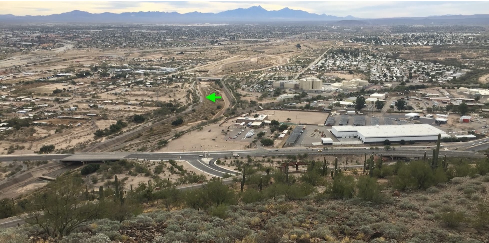
Note the dry, channelized, artificially straightened riverbed and how much of the watershed’s vegetative sponge has been replaced with pavement, buildings, or bare compacted earth. The watershed now drains more rainfall than it absorbs. During storms, flooding water erosively rips unchecked through the watershed and straightened river channel to cause flooding problems downstream. Summer temperatures are rising due to the heat absorbed within the exposed pavement and bare soil.
Green arrow denotes location of where the Santa Cruz River Heritage Project in 2019 began pumping treated sewage water into the river bed to artificially recharge the groundwater and reestablish riparian vegetation within the river bed.
Photo: Brad Lancaster
When looking at the Tucson Basin, note its basin and range topography of the surrounding mountains and the relatively flat basin in between. That flat basin was formed from all the rock, gravel, soil, and other sediment eroded from the mountains and deposited within what used to be a much lower/deeper basin.
Tucson’s groundwater is stored within all the tiny pore spaces between the various particles of deposited sediment that make up the ground of the Tucson basin. Tucson’s underground aquifer is made up of all those trillions of tiny pore spaces between the sediment particles.
In our hot and dry environment, underground storage of water is very efficient, because you don’t lose that water to evaporation, as you would if the water were stored on the hot, exposed surface, as is the case with lakes, ponds, and reservoirs.
I like to think of our groundwater as our community’s savings account. That account is balanced as long as natural recharge of the groundwater is in balance with its extraction/pumping. But with the arrival of mechanical pumps in the early 1900s, we have been pumping our groundwater at a rate that exceeds natural recharge. Thus, we are rapidly depleting our savings account; but this need not be the case.
I personally put more water into the community’s groundwater bank account each year than I take out. This is easily done by using harvesting rainwater and stormwater as my primary water sources. Recycled household greywater is my secondary water source. And groundwater is only used as a backup water source reserved for true times of need. See the latest, full-color editions of my books Rainwater Harvesting for Drylands and Beyond for various ways you too could do this.
The “A” on the peak was built by University of Arizona (UA) students in 1916.
You can walk, bicycle, or drive near the very top, then hike up the last short bit to the very top where you can look south and compare the view below from the early 1900s to today.
Where:
1001 S. Sentinel Peak Rd., Tucson AZ 85745
32°12’37.2″N 110°59’32.1″W
Hours: Sunrise-Sunset
Motorized vehicle Access:
Monday: no vehicle access
Tuesday-Thursday: 2 p.m.-sunset
Friday-Sunday: 11 a.m.-sunset
Cost: free
Dogs allowed on leash
This location is included in the following tours:
See the new, full-color, revised editions of Brad’s award-winning books
– available a deep discount, direct from Brad:
Volume 1