Central Avra Valley Storage and Recovery Project (CAVSARP)
The CAVSARP recharge basins allow Colorado River water pumped uphill via the CAP canal to Avra Valley (west of Tucson) to infiltrate the soil below and migrate down to the groundwater table. That groundwater blended with the artificially recharged CAP water is then pumped back out, pumped over the Tucson Mountains to a treatment plant in Tucson, where it is treated, then is pumped into Tucson water lines and delivered to homes and businesses.
Basins are scheduled to have one extensive dry period per year to improve water infiltration, enable the soil to become more aerobic (having oxygen), and maintain the basin (this includes raking the surface of the soil). Without this drying time and maintenance, the bottom of the basins would “clog” with infiltration rates decreasing as anaerobic (lacking oxygen) soil conditions would become dominate after prolonged continual submergence below water, and sediment accumulation (of clays for example) would build up.
Photo: Brad Lancaster
In the 1970s, the City of Tucson purchased the land where the CAVSARP basins are now located, to retire the land from agricultural use and secure the rights for the groundwater under the land for use by Tucson.
In 2003 the CAVSARP facility was completed. It includes 11 recharge basins totaling 317 acres, 33 recovery wells, a reservoir, booster station and pipeline.
According to Tucson Water, “Water quality issues that occurred when Colorado River water was first delivered to Tucson Water customers in 1992-94 led to the passage of Proposition 200: the Water Consumer Protection Act, which prevents delivery of CAP water directly to customers. To meet the requirements of the Act, Tucson Water developed CAVSARP to recharge, store and recover a blend of Colorado River water and native groundwater. This allowed the City to shut down many of its groundwater wells serving urban Tucson.”
A sister underground storage project called Southern Avra Valley Storage and Recovery Project (SAVSARP) was completed in 2009 a few miles to the south of CAVSARP.
Tucson Water uses the two projects together to manage most of Tucson’s annual allocation of Colorado River water.
Some things to consider
44% of the City of Tucson’s energy consumption is used to move and treat water. (See the Watergy section of the Tucson One-Page Place Assessment).
Note that comparatively, rainwater is delivered to us free of charge and with zero energy consumption.
Since Tucson began artificially recharging its groundwater with imported CAP water, the groundwater level in some areas has risen, but at the same time the salt content in Tucson’s groundwater has doubled compared to pre-CAP water importation.
From 1978 to 1990 (pre-CAP water arrival) the total dissolved solids (TDS) in groundwater delivered by Tucson’s water utility were 280 mg/L—much of that being salt that can harm plants and other soil life if it becomes too concentrated.
The CAP canal provides water having a TDS of 605 mg/L.
Colorado River has a high TDS content due in part to its vast dryland watershed, along which runoff flows pick up a lot of sediment; and because as water evaporates from the large reservoirs behind dams on the river, and from the CAP canal, salts become more concentrated in the water that remains.
Note that rainwater contains no salt, it is naturally distilled water. But rainwater runoff can pick up salts as the water runs off surfaces like bare soil containing salt. The larger and less vegetated the salty surface the water runs over, the more the water will pick up salty sediment. So, harvest your rainfall as close as possible to where it falls, and keep your watersheds vegetated.
We should be doing this in both our urban and rural areas. The Avra Valley watershed (in which CAVSARP is located) has lost a great deal of its former vegetative cover, natural wetlands, and connection of its (now erosively downcut) waterways to their adjoining floodplains onto which larger storm flows could (pre-dowcutting) spread and infiltrate the soil and aquifer. See here for some strategies helping restore some of the Altar Valley watershed (a subwatershed within the Avra Valley watershed), along with information on what originally caused much of the erosion and vegetative loss in the watershed.
Where:
Located just southwest of the intersection of Sandario Road and Mile Wide Road west of Tucson in Avra Valley at: 32.22821880182293, -111.23776017298069
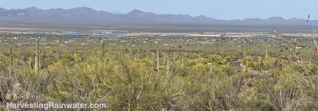
This site is NOT open to the public, so view from the public viewing area below…
The project’s recharge basins are best (or most conveniently) viewed from scenic pull out off N Kinney Road on the way to Saguaro National Park West at:
32.24723777608315, -111.17513198135225
Hours: the scenic N. Kinney Road pull-off viewpoint is always open, but you can only see the recharge basins in daylight hours.
Cost: Free
This location is included in the following tours:
See the new, full-color, revised editions of Brad’s award-winning books
– available a deep discount, direct from Brad:
Volume 1