Where rocks have made the water flow: a water-harvesting Arizona ranch
Chiricahua Mountains, southern Arizona, USA
By Brad Lancaster
www.HarvestingRainwater.com
The following is a revised excerpt from the first edition of my book Rainwater Harvesting for Drylands and Beyond, Volume 2…
Nestled in the western foothills of the Chiricahua Mountains of southeastern Arizona at about 6,000 feet elevation sits El Coronado Ranch. The surrounding grasslands are mottled with oak, juniper, and pinyon pines. Rainfall varies from 7 to 30 inches (177–762 mm) per year yet El Coronado Ranch is a lush oasis in this high desert, with flowing streams, thick grasslands, and abundant wildlife. But things weren’t always so.
When Joe and Valer Austin bought El Coronado Ranch in 1982 erosion was severe on the 2,000 deeded acres. Water flowed in the creeks only during the rainy season, and many of the creek beds were eroded down to bedrock. Surveying the land just after purchase they wondered, “What do the cattle eat?” Barren outcrops of bedrock and bare soil were more prominent than grassy areas.
In 2022, just before the Austins sold the ranch, if you look across the land following rains you see water flowing and seeping in and around most of the washes. In some streams water now flows year round. Once bare bedrock is now blanketed with a thick, spongy carpet of fertile soil and grass. Water bugs, fish, ducks, and turtles have returned along with the water to the streams. Cottonwood and willow trees are volunteering where previously there were none. No hunting is allowed on the ranch, yet local hunters complain that all the deer live here. “Well,” Joe explains, “where you have water, you’ve got life.”
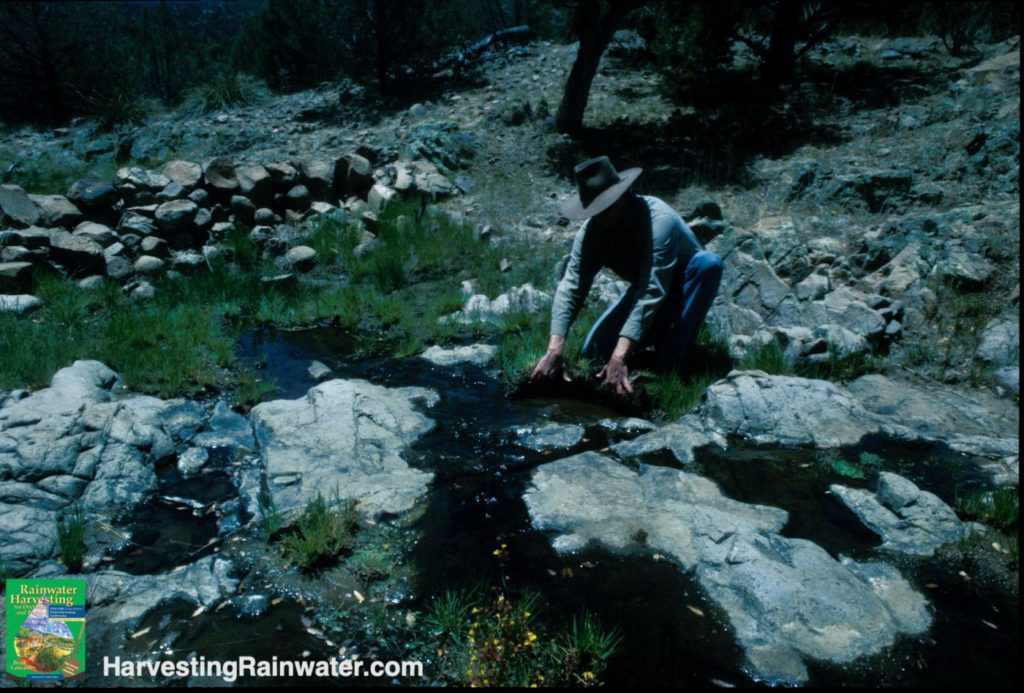
Photo: Brad Lancaster, winter 2004
What has brought on this dramatic and bountiful change?
Simply put, the Austins and their ranch hands slowed and spread the water flow in a way that allowed water to linger longer in the land’s living soils, which then grew more vegetation that enhanced the lingering further still.
There are many ways one can do this, each suited to different unique site conditions, as the new full-color editions of my books Rainwater Harvesting for Drylands and Beyond show.
The Austins did so by laying rocks perpendicular to the slope. Specifically, they built loose-rock check dams, lots of them.
Slowing the water’s flow
Joe and Valer built their first check dam on the downslope side of their driveway where it crossed a small waterway. They used materials at hand—rocks, old concrete footing, and broken bricks. Soil was trapped and held in place by the check dam, the road stopped washing out, and a seep formed downslope lingering long after the rains, supporting a lush growth of grass.
“Hey,” they thought, “if this check dam can do this much here where it’s relatively dry, let’s see what others can do where more water flows!”
Thinking broad
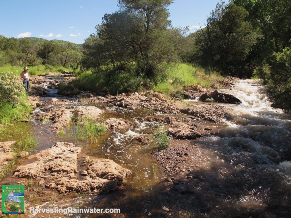
Over the next 10 years they put in more than 20,000 loose-rock check dams on their 2,000 deeded acres plus still more on the 14,000 acres they leased. Two watersheds have been treated with check dams running from the top to the bottom of the main drainages, and many more scattered over the minor drainages, dips, and slopes leading into the main waterways. The results are impressive.
The 180-acre Bedrock watershed used to run one month of the year but as of my first visit in 2004, it had run 34 months straight. The 2,000-acre Turkey Pen watershed would run three months of the year but now pools of water linger where before there were none, and water flows almost year round. The system quietly works and builds on itself.
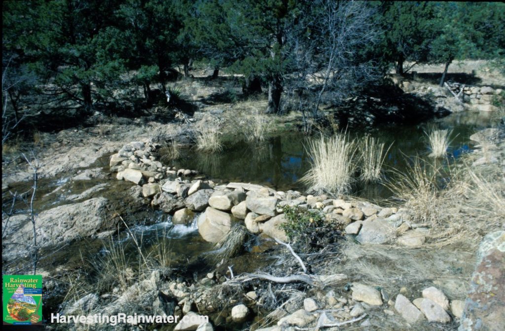
Photo: Brad Lancaster, winter 2004
Runoff is calmed as flow is dispersed by the creek’s naturally meandering pattern, and how the check dams have accumulated soil, which has lifted the bed of the water channel to more readily reconnect water flow with the channel’s much wider floodplain. As water spills out over, and infiltrates into, the floodplain there is far more soil-water contact, and infiltration of water into the soil, which is then slowly released subsurface from the soil back to the creek over a period of weeks and months, thereby lengthening the creek’s flow much longer into the dry season.
That lingering moisture also grows more vegetation, which also helps slow and spread the water flow and catch and hold sediment, while generating more wildlife habitat, livestock fodder, erosion control, organic matter and soil fertility, and shading/cooling/sheltering the high desert land. “Set up the right conditions,” Valer says, “and both the plants and the soil will volunteer.”
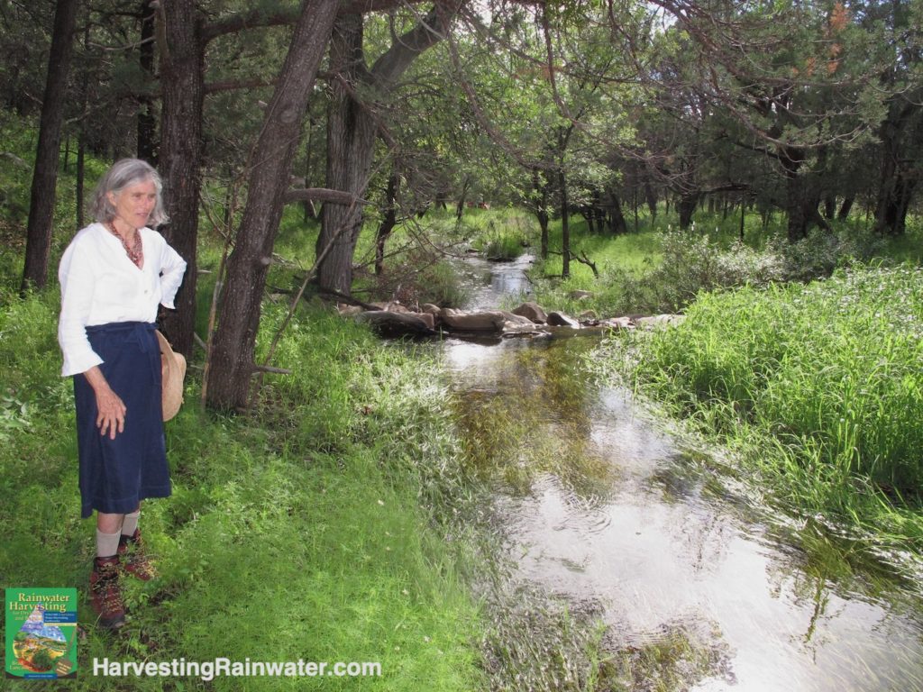
Photo: Brad Lancaster, summer 2014
Working small
When asked how big he makes his check dams, Joe replied, “I’d rather make them smaller and put in more total check dams than make them bigger and put in fewer.” He starts at the top of the watershed explaining, “The bottom of the watershed is just the tip of the watershed iceberg. Start at the top and you can keep all the work you do at the bottom.”
See the water-harvesting principles for more on this.
Water-harvesting structures placed at the bottom of the watershed with nothing upslope in an eroded watershed could necessitate huge, engineered, machine-built structures, which can bring on disaster if they fail. The Austins’ check dams are too small to cause much trouble if they fail, ranging from 6 inches (15 cm) to 3 feet (1 meter) in height and built by hand. However, of 200 check dams observed, researcher Craig Sponholtz noted that “approximately 30% had been compromised by end-cutting or significant plunge pool scouring.”1
The end-cutting could have been reduced if the flat-topped dams had been built more banana-like in shape with a low spot in the middle of the drainage, and the ends of the banana extending further up the banks. The plunge pool scouring could have been reduced if grade control structures such as one-rock dams had been constructed on the downslope side of the plunge pools where the dams were built atop soil rather than bedrock. Shorter, more gradually sloped structures would also reduce the vertical fall of water on their downstream side, which would reduce the amount of scouring in the downstream plunge pool.
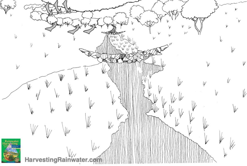
Illustration: Silvia Rayces
Small check dams can utilize free, on-site materials. The Austins didn’t spend a cent on materials, instead they used local stone and debris with no added wire or gabion baskets. Skilled workers were hired to build the dams, with a four-person team putting in 10 structures a day. Some may say that labor costs make such work unaffordable. Valer argues that you can’t afford not to do the work. If you don’t do anything in such an eroded environment you lose topsoil, organic matter, water, and productivity each year. If you put in small water-harvesting systems you gain soil, organic matter, water, vegetation, and greater productivity each year. These strategies don’t drain the system, they feed it.
The Austins run 200 to 300 head of cattle under an efficient system of rotation that has helped heal the land. Animals are allowed in riparian areas only during the vegetation’s dormant season. Young trees are fenced to insure they will grow into large trees. Water and grass are now more widely available so cattle use less energy searching for food and water, maintain good weight and health, and return higher profits.
No less valuable is the growing diversity and density of wildlife, which improves the ecosystem and furthers its potential to achieve still higher levels of health and succession. Yaqui chub, an endangered native fish, has been reintroduced to the watershed and can be seen darting around the rare Sonoran mud turtles that thrive at El Coronado. Thick-billed parrots perch on cottonwood and willow trees spreading the seed they eat throughout their range.
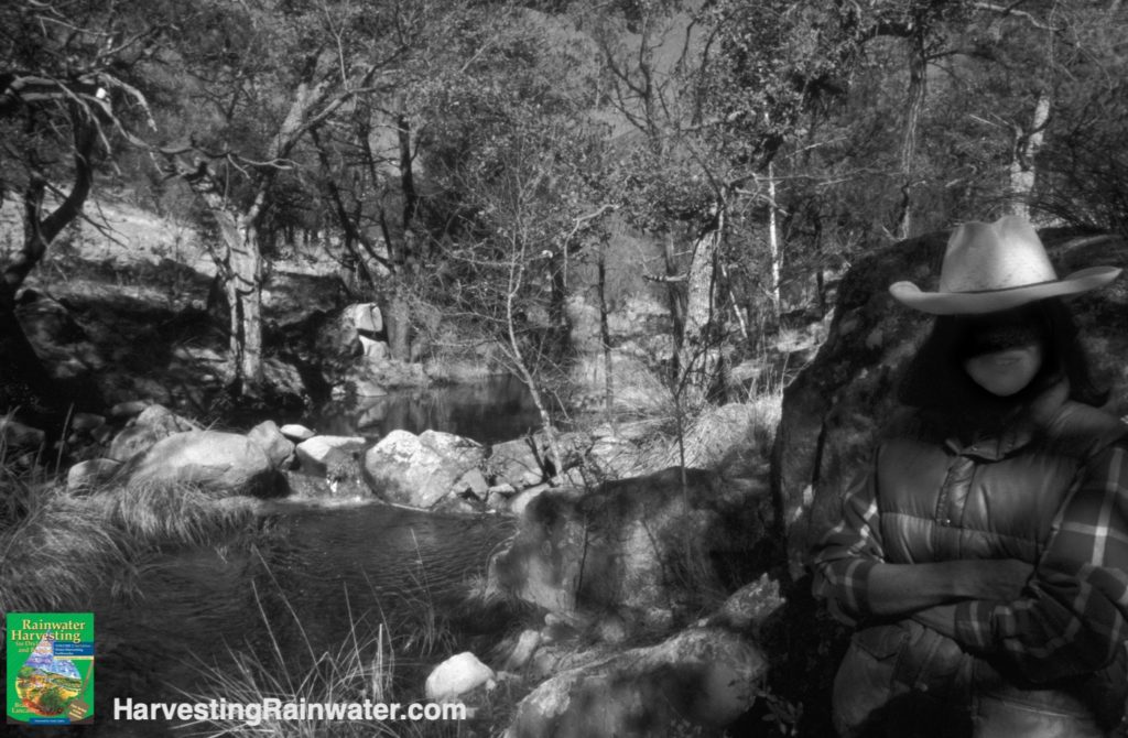
Photo: Brad Lancaster, winter 2004
Calm the flow, but don’t stop it
When the Austins began, local folks said the ponds below their check dam work would never fill again, but they filled the first year after check dam construction and have maintained their water levels better than before. Downstream neighbors have benefited from rising well levels. With check dams in place, and a healthier watershed, stormwater now meanders gently through the land over a period of weeks and months, rather than ripping through in a matter of hours.
Research backs this up finding that the ranch’s check dam-treated watershed:
• Reduced peak flood events in half.2
• Increased surface flows into the dry season by 28% when compared to a similar, neighboring and untreated watershed.3
• These structures bring much needed water back into ecosystems, while storing carbon and sediment on par with coastal wetlands.4
Rock Creek on right with cloudy, sediment-laden water comes from non-stabilized watershed,
Photo: Brad Lancaster, summer 2014
As Joe sat on a thick cushion of vegetation with water bubbling by he reflected. “Had I been told I needed to put in thousands of stone structures I’d still be thinking about that. You just have to start.”
The good news is that even one well-placed, -designed, and -built structure can begin the healing process. At El Coronado they just kept going.
10-minute video documentary on the Austin’s work at El Coronado Ranch
Watch “Re-Greening a Dryland Watershed” by the U.S. Geological Survey in the link below:
https://www.usgs.gov/media/videos/re-greening-dryland-watershed
The video link includes references to more of the extensive research done on the check dam work.
Potential of working smarter
Every year crews were hired to repair structures on El Coronado Ranch and build more. Such maintenance is a good practice, though after many conversations with Craig Sponholtz of Watershed Artisans, and studying with Bill Zeedyk, co-author of Let the Water Do the Work, I believe smarter design more intentionally harmonized with natural patterns and processes could have significantly reduced maintenance and attained the same effect with fewer structures and less overall rock.
So, what do I mean by that?
Here’s an example…
If the check dams were only built on the crossover riffle (middle of straight section between channel meanders, where channel depth tends to be most shallow, and where water flow is fairly even across the width of the channel), there would be less likelihood of the structures getting blown out/eroded as occurs when they are built in a meander or curve of a channel (where there is more force on the outer bend than the inner bend of the curve, and the outer bank tends to get eroded while a pool forms below).
I elaborate on such patterns of water and sediment flow in chapter 10 of the new, full-color edition of Rainwater Harvesting for Drylands and Beyond, Volume 2, 2nd Edition, and illustrate still more patterns in appendix 1 of Rainwater Harvesting for Drylands and Beyond, Volume 1, 3rd Edition, so you can consciously collaborate with, rather than unconsciously fight, these natural patterns.
Wiser placement of structures can enable the effective use of smaller, easier-to-build, structures that require far less rock, and utilize plants to grow the height and strength of the structures. An example being the one-rock dam, which is only one rock high, so vegetation can much more readily grow between the rock compared to a structure multiple rocks high. The one-rock dams (ORDs) are less likely to blow out/fail than a taller, multi-rock-high structure, such as a check dam, since the ORDs create less of barrier or wall in the water’s flow. Once the ORD fills with sediment on its upstream side, you can then build a second one atop the first, using the lower half of the original structure as the downstream stabilized spillway. This way you just create small rises in the water’s flow that are more like gradual speed humps, rather than the vertical walls check dams often create, so the ORDs are more likely to beneficially silt up, than erosively blow out.
See chapter 10 of Rainwater Harvesting for Drylands and Beyond, Volume 2, 2nd Edition for more info on how to place, build, and raise (with a second level after the first silts up) one-rock dams.
And there are many more strategies than the ORDs that can also better harmonize with natural patterns and processes than check dams. But what makes them similar to the check dams is they all help slow and spread the water as it flows through the watershed, so more water can infiltrate the soil and vegetation in high flows, and then be more slowly released longer into the dry times.
REFERENCES
1. Craig Sponholtz, Agroecological Restoration in Southwestern Woodlands: A Comparative Analysis of Water Harvesting and Erosion Control Methods, July 2005. Contact Craig at Watershed Artisans.com
2.Norman, L.M., Brinkerhoff, F., Gwilliam, E., Guertin, D.P., Callegary, J., Goodrich, D.C., Nagler, P.L., Gray, F., 2016. Hydrologic Response of Streams Restored with Check Dams in the Chiricahua Mountains, Arizona. River Res. Applic. 32, 519–527. https://doi.org/10.1002/rra.2895
3.Norman, L.M., Brinkerhoff, F., Gwilliam, E., Guertin, D.P., Callegary, J., Goodrich, D.C., Nagler, P.L., Gray, F., 2016. Hydrologic Response of Streams Restored with Check Dams in the Chiricahua Mountains, Arizona. River Res. Applic. 32, 519–527. https://doi.org/10.1002/rra.2895
4. “Re-Greening a Dryland Watershed” by the U.S. Geological Survey https://www.usgs.gov/media/videos/re-greening-dryland-watershed
For more on different water harvesting strategies in the ranch/farm/rural context see:
Harvesting Rainwater for Hikers, Wildlife, Livestock, Oases, and More
Evolutions on Mr. Phiri’s Water-Harvesting Plantation, 1995–2016
The Abundance Growing from the Water-, Soil-, and Fertility-Harvesting of Bouwas Mawara in Zimbabwe
For still more, including step-by-step implementation guidance…
See the new, full-color, revised editions of Brad’s award-winning books
– available a deep discount, direct from Brad:
Volume 1
This is THE book to start with.
It gives you the integrated vision, concepts, and approach.
And be sure to read appendix 1: Patterns of Water and Sediment Flow with Their Potential Water-Harvesting Response.
Volume 2
This book gives you step-by-step instructions on how to create many different types of water-harvesting earthworks for different conditions and contexts, and grow well-suited vegetation that will thrive without you after establishment.
Be sure to read the book’s water-harvesting principles and the various case studies and stories of people applying those principles for different effects in different contexts.
And read the natural patterns and principles specific to in-channel strategies, and their examples in chapter 10.