How to use Google Maps or Google Earth Pro to figure out a site’s rainwater catchment area(s) and rainfall income
by Brad Lancaster, HarvestingRainwater.com
You can use the online version of Google Maps at https://www.google.com/maps
For Google Earth Pro, you need to download the app onto your computer or smart phone.
Look up the site on the app, choose “satellite” view, and zoom in as you like.
As you zoom in, your view may tilt. I hate that, as you want the view from directly overhead. Search on-line for how to get rid of the tilt (the method seems to change as they update the apps, or depending on what device you are using). As of this writing, on a laptop, you can get rid of the tilt by simultaneously hitting the Shift and U keys on your keyboard.
Note: on Google Earth Pro you can rotate your view, whereas I haven’t figured out how to do so on Google Maps.
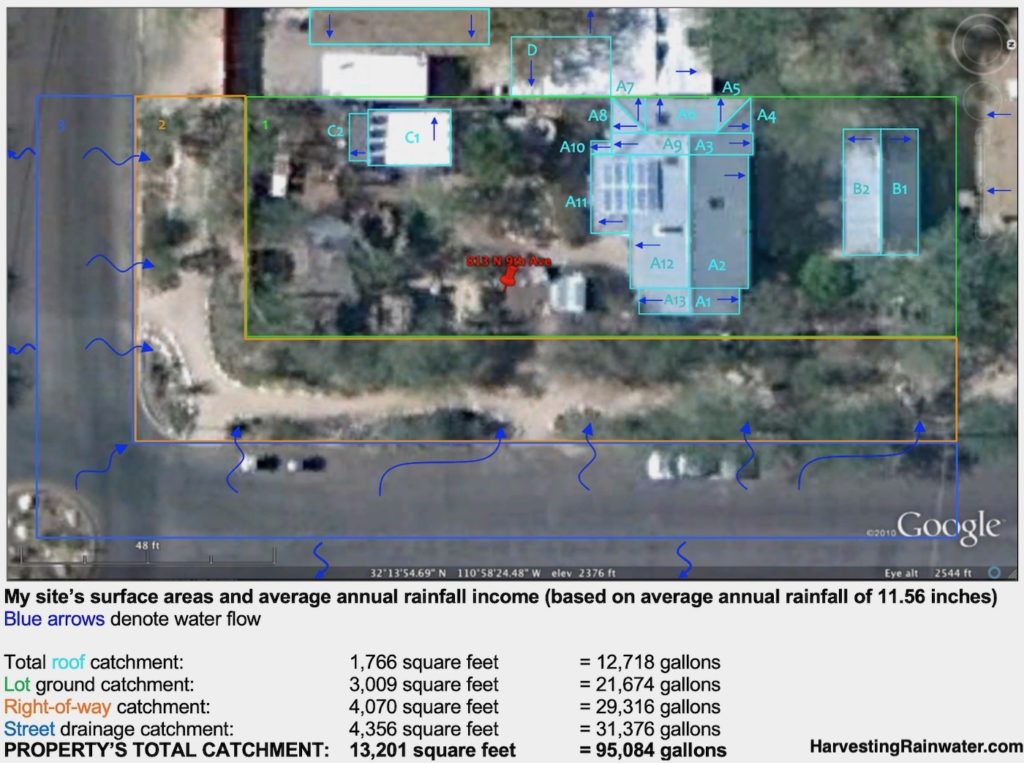
Delineate catchment area boundaries and direction of water flow
After taking a screen shot of the Google Maps or Google Earth Pro image, I typically do this on a mac computer in:
• the Photos app where I upload the image then select Edit, then Markup (the three horizontal dots in a circle on the menu bar) to overlay the catchment boundary lines and flow arrows
or
• I use the Power Point app where I upload the image then select Insert, then Shapes to overlay the catchment boundary lines and flow arrows
To make sure I have the right water flow directions I physically inspect the site. If I can see the roof and its slopes, I get a ladder, climb onto the roof, and inspect the roof slopes and rainwater gutters or outlets.
On flatter sites where slope direction may not be visually obvious, use a water level (bunyip level), A-frame level, or laser level. All described, including how you make and use them in Appendix 1 of Rainwater Harvesting for Drylands and Beyond, Volume 2, 2nd Edition.
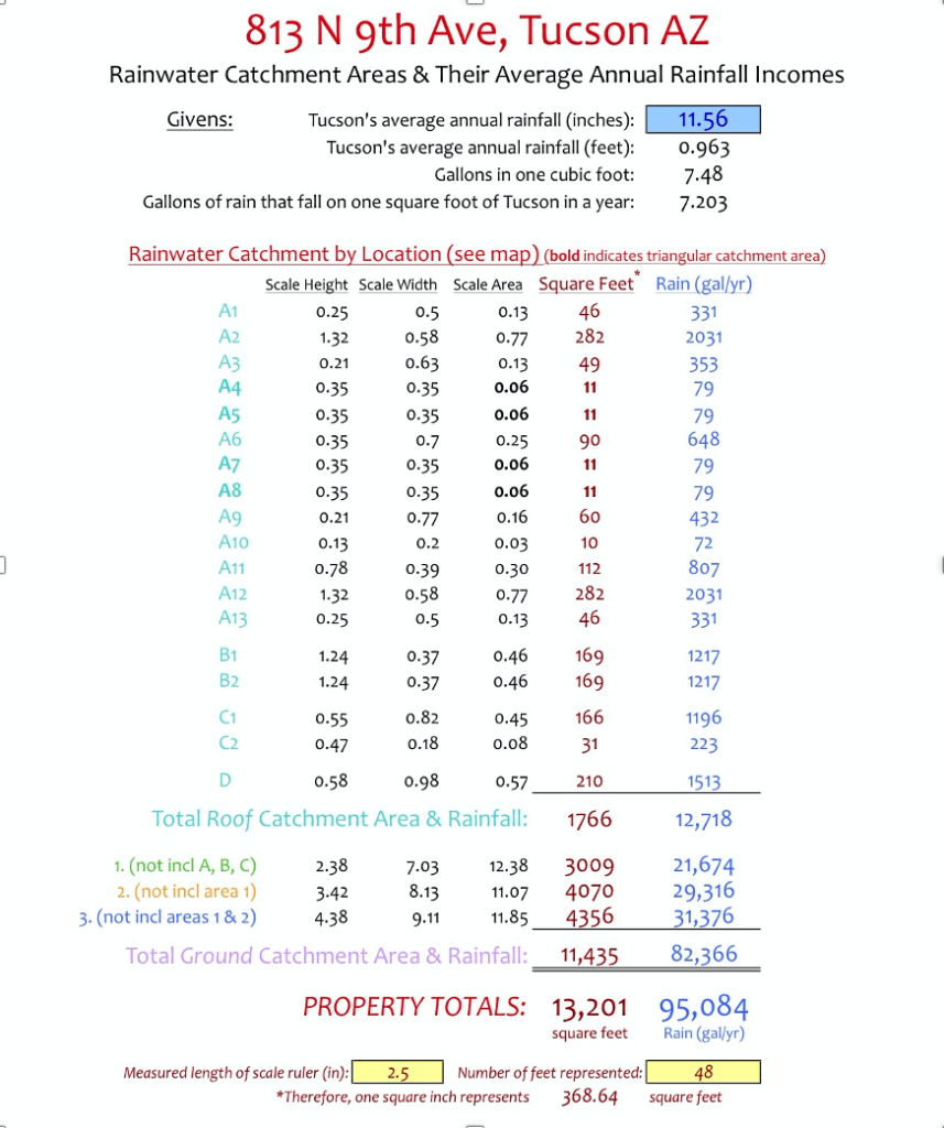
Using the scale on the aerial view – a method requiring you to use a ruler and do some simple math to figure out your catchment’s surface area(s)
You can use the scale on the image (see bottom left corner of image above), to measure/estimate the length (in feet) and width (in feet) of your various catchment areas to get their surface areas in square feet.
If using metric measurements – use meters, to get your surface areas in square meters.
To keep the math simple, I break the catchment areas into squares, rectangles, or triangles.
For a square or rectangle, multiply its length by its width to get the surface area in square feet or square meters.
For a triangle, multiply its base by its height, then divide by 2 to get the surface area.
For examples, more clear explanations of the math, and other equations see the calculations appendix of Rainwater Harvesting for Drylands and Beyond, Volume 1, 3rd Edition
Using Google Earth Pro – to do the measuring and math for you
Check out the video below to see how you can use Google Earth Pro to measure and calculate the surface area of your catchment areas.
Calculating rainfall volumes for your catchment area(s)
Once you have your surface areas figured out you can then calculate how much rain falls on each catchment surface area by multiplying the catchment area’s surface area by the volume of rain falling on that surface.
An example in English units is:
CATCHMENT AREA (ft2) x RAINFALL (ft) = TOTAL RAINWATER (ft3)
If you are like me, you normally measure rainfall in inches, not feet, then divide inches of rain by 12 (there are 12 inches in a foot) to get rainfall in feet. So, for our example site receiving 11.56 inches of annual rainfall, I divide 11.56 by 12 = 0.96 feet.
To convert cubic feet (ft3) of rainwater to gallons, multiply the cubic feet figure by 7.48.
(There are 7.48 gallons of water in a cubic foot of water).
For a more clear and thorough explanation of these and other calculations (including in metric), along with examples, see Box 2.3, and the calculations appendix of Rainwater Harvesting for Drylands and Beyond, Volume 1, 3rd Edition.
Here is a breakdown of the catchment areas and their average annual rainfall volumes for the image at the top of this blog post…
See the new, full-color, revised editions of Brad’s award-winning books
– available a deep discount, direct from Brad:
Volume 1
Read Chapter 2: Assessing Your Site’s Water Resources and More
See Appendix 3: Water-Harvesting Calculations.
And see appendix 4 to estimate the water needs of your landscape or garden, so you can figure out what you can sustain with your free, on-site waters (such as rainwater, street runoff/stormwater, greywater, condensate, and more).
And see the simple tables that enable you to estimate the volume of your site’s greywater, condensate, and more.
Volume 2
Appendix 1: Water Levels, A-Frame Levels, and Laser Levels is a must have for this site assessment work, while the rest of the book is instrumental in showing you many different ways in many different contexts you can plant rain, greywater, and other free on-site water sources for maximum effect.